Zip Codes with the Highest Percentage of Households Heated by Bottled Gas / Liquid Propane in Rhode Island
RELATED REPORTS & OPTIONS
Bottled Gas / LP Heating
Rhode Island
Compare Zip Codes
Map of Zip Codes with the Highest Percentage of Households Heated by Bottled Gas / Liquid Propane in Rhode Island
0.0%
25.0%
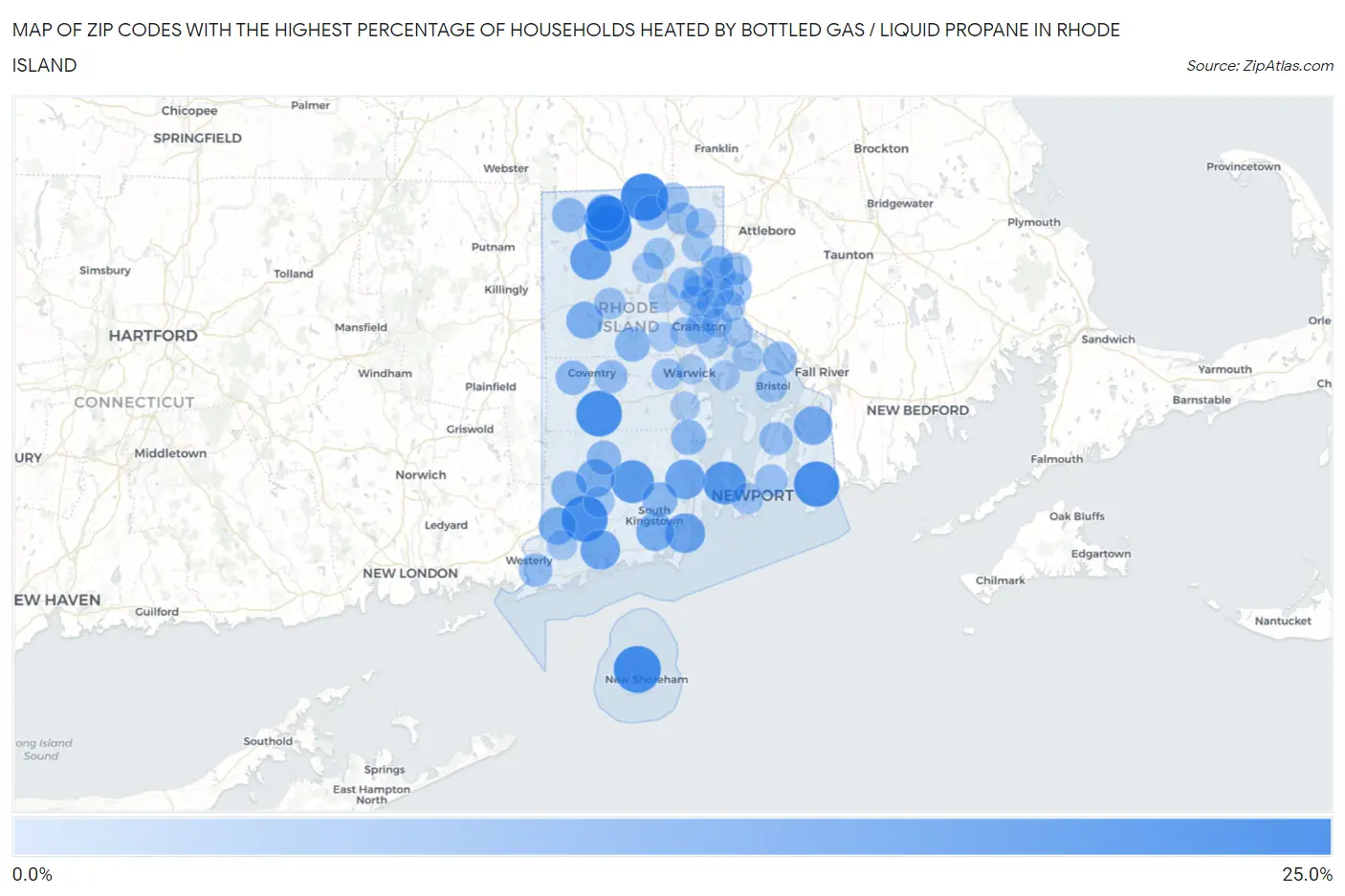
Zip Codes with the Highest Percentage of Households Heated by Bottled Gas / Liquid Propane in Rhode Island
| Zip Code | Bottled Gas / LP Heating | vs State | vs National | |
| 1. | 02824 | 21.4% | 4.3%(+17.1)#1 | 4.9%(+16.5)#8,426 |
| 2. | 02807 | 21.1% | 4.3%(+16.8)#2 | 4.9%(+16.2)#8,546 |
| 3. | 02894 | 19.8% | 4.3%(+15.5)#3 | 4.9%(+14.9)#9,034 |
| 4. | 02817 | 19.6% | 4.3%(+15.3)#4 | 4.9%(+14.7)#9,098 |
| 5. | 02839 | 19.6% | 4.3%(+15.3)#5 | 4.9%(+14.7)#9,108 |
| 6. | 02837 | 19.3% | 4.3%(+15.0)#6 | 4.9%(+14.4)#9,220 |
| 7. | 02858 | 19.2% | 4.3%(+14.9)#7 | 4.9%(+14.3)#9,282 |
| 8. | 02835 | 16.3% | 4.3%(+12.0)#8 | 4.9%(+11.4)#10,648 |
| 9. | 02892 | 16.1% | 4.3%(+11.8)#9 | 4.9%(+11.2)#10,743 |
| 10. | 02814 | 14.0% | 4.3%(+9.70)#10 | 4.9%(+9.10)#11,851 |
| 11. | 02882 | 12.8% | 4.3%(+8.50)#11 | 4.9%(+7.90)#12,520 |
| 12. | 02874 | 12.5% | 4.3%(+8.20)#12 | 4.9%(+7.60)#12,738 |
| 13. | 02813 | 12.4% | 4.3%(+8.10)#13 | 4.9%(+7.50)#12,807 |
| 14. | 02878 | 11.1% | 4.3%(+6.80)#14 | 4.9%(+6.20)#13,683 |
| 15. | 02898 | 10.7% | 4.3%(+6.40)#15 | 4.9%(+5.80)#13,972 |
| 16. | 02879 | 10.5% | 4.3%(+6.20)#16 | 4.9%(+5.60)#14,082 |
| 17. | 02804 | 9.8% | 4.3%(+5.50)#17 | 4.9%(+4.90)#14,617 |
| 18. | 02830 | 9.4% | 4.3%(+5.10)#18 | 4.9%(+4.50)#14,877 |
| 19. | 02825 | 9.2% | 4.3%(+4.90)#19 | 4.9%(+4.30)#15,053 |
| 20. | 02832 | 8.0% | 4.3%(+3.70)#20 | 4.9%(+3.10)#15,963 |
| 21. | 02881 | 7.3% | 4.3%(+3.00)#21 | 4.9%(+2.40)#16,523 |
| 22. | 02831 | 7.2% | 4.3%(+2.90)#22 | 4.9%(+2.30)#16,616 |
| 23. | 02852 | 7.0% | 4.3%(+2.70)#23 | 4.9%(+2.10)#16,730 |
| 24. | 02896 | 6.4% | 4.3%(+2.10)#24 | 4.9%(+1.50)#17,250 |
| 25. | 02859 | 6.4% | 4.3%(+2.10)#25 | 4.9%(+1.50)#17,258 |
| 26. | 02822 | 6.4% | 4.3%(+2.10)#26 | 4.9%(+1.50)#17,262 |
| 27. | 02827 | 6.4% | 4.3%(+2.10)#27 | 4.9%(+1.50)#17,285 |
| 28. | 02885 | 5.7% | 4.3%(+1.40)#28 | 4.9%(+0.800)#17,841 |
| 29. | 02891 | 5.4% | 4.3%(+1.10)#29 | 4.9%(+0.500)#18,103 |
| 30. | 02871 | 5.2% | 4.3%(+0.900)#30 | 4.9%(+0.300)#18,323 |
| 31. | 02860 | 5.0% | 4.3%(+0.700)#31 | 4.9%(+0.100)#18,503 |
| 32. | 02816 | 4.9% | 4.3%(+0.600)#32 | 4.9%(=0.000)#18,617 |
| 33. | 02916 | 4.6% | 4.3%(+0.300)#33 | 4.9%(-0.300)#18,995 |
| 34. | 02861 | 4.4% | 4.3%(+0.100)#34 | 4.9%(-0.500)#19,182 |
| 35. | 02842 | 4.4% | 4.3%(+0.100)#35 | 4.9%(-0.500)#19,197 |
| 36. | 02838 | 4.3% | 4.3%(=0.000)#36 | 4.9%(-0.600)#19,363 |
| 37. | 02809 | 4.0% | 4.3%(-0.300)#37 | 4.9%(-0.900)#19,629 |
| 38. | 02908 | 3.8% | 4.3%(-0.500)#38 | 4.9%(-1.10)#19,847 |
| 39. | 02863 | 3.8% | 4.3%(-0.500)#39 | 4.9%(-1.10)#19,866 |
| 40. | 02911 | 3.7% | 4.3%(-0.600)#40 | 4.9%(-1.20)#20,001 |
| 41. | 02917 | 3.4% | 4.3%(-0.900)#41 | 4.9%(-1.50)#20,399 |
| 42. | 02895 | 3.3% | 4.3%(-1.000)#42 | 4.9%(-1.60)#20,516 |
| 43. | 02840 | 3.3% | 4.3%(-1.000)#43 | 4.9%(-1.60)#20,552 |
| 44. | 02857 | 3.3% | 4.3%(-1.000)#44 | 4.9%(-1.60)#20,584 |
| 45. | 02914 | 3.2% | 4.3%(-1.10)#45 | 4.9%(-1.70)#20,696 |
| 46. | 02907 | 3.1% | 4.3%(-1.20)#46 | 4.9%(-1.80)#20,847 |
| 47. | 02906 | 3.1% | 4.3%(-1.20)#47 | 4.9%(-1.80)#20,864 |
| 48. | 02909 | 3.0% | 4.3%(-1.30)#48 | 4.9%(-1.90)#20,991 |
| 49. | 02893 | 2.9% | 4.3%(-1.40)#49 | 4.9%(-2.00)#21,184 |
| 50. | 02828 | 2.7% | 4.3%(-1.60)#50 | 4.9%(-2.20)#21,610 |
| 51. | 02812 | 2.7% | 4.3%(-1.60)#51 | 4.9%(-2.20)#21,655 |
| 52. | 02865 | 2.4% | 4.3%(-1.90)#52 | 4.9%(-2.50)#22,213 |
| 53. | 02806 | 2.2% | 4.3%(-2.10)#53 | 4.9%(-2.70)#22,698 |
| 54. | 02904 | 2.1% | 4.3%(-2.20)#54 | 4.9%(-2.80)#22,874 |
| 55. | 02888 | 2.1% | 4.3%(-2.20)#55 | 4.9%(-2.80)#22,948 |
| 56. | 02864 | 2.0% | 4.3%(-2.30)#56 | 4.9%(-2.90)#23,151 |
| 57. | 02910 | 2.0% | 4.3%(-2.30)#57 | 4.9%(-2.90)#23,211 |
| 58. | 02808 | 1.9% | 4.3%(-2.40)#58 | 4.9%(-3.00)#23,612 |
| 59. | 02920 | 1.7% | 4.3%(-2.60)#59 | 4.9%(-3.20)#24,000 |
| 60. | 02915 | 1.7% | 4.3%(-2.60)#60 | 4.9%(-3.20)#24,118 |
| 61. | 02919 | 1.6% | 4.3%(-2.70)#61 | 4.9%(-3.30)#24,380 |
| 62. | 02886 | 1.5% | 4.3%(-2.80)#62 | 4.9%(-3.40)#24,727 |
| 63. | 02889 | 1.5% | 4.3%(-2.80)#63 | 4.9%(-3.40)#24,744 |
| 64. | 02905 | 1.3% | 4.3%(-3.00)#64 | 4.9%(-3.60)#25,509 |
| 65. | 02818 | 1.3% | 4.3%(-3.00)#65 | 4.9%(-3.60)#25,561 |
| 66. | 02921 | 1.1% | 4.3%(-3.20)#66 | 4.9%(-3.80)#26,386 |
| 67. | 02903 | 1.0% | 4.3%(-3.30)#67 | 4.9%(-3.90)#26,834 |
1
Common Questions
What are the Top 10 Zip Codes with the Highest Percentage of Households Heated by Bottled Gas / Liquid Propane in Rhode Island?
Top 10 Zip Codes with the Highest Percentage of Households Heated by Bottled Gas / Liquid Propane in Rhode Island are:
What zip code has the Highest Percentage of Households Heated by Bottled Gas / Liquid Propane in Rhode Island?
02824 has the Highest Percentage of Households Heated by Bottled Gas / Liquid Propane in Rhode Island with 21.4%.
What is the Percentage of Households Heated by Bottled Gas / Liquid Propane in the State of Rhode Island?
Percentage of Households Heated by Bottled Gas / Liquid Propane in Rhode Island is 4.3%.
What is the Percentage of Households Heated by Bottled Gas / Liquid Propane in the United States?
Percentage of Households Heated by Bottled Gas / Liquid Propane in the United States is 4.9%.