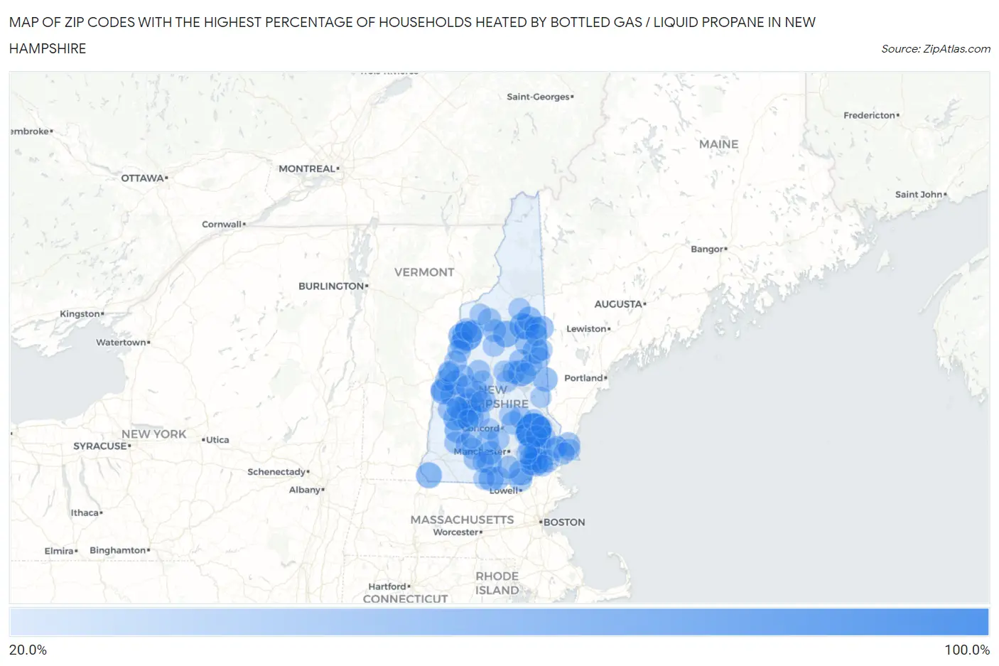
Zip Codes with the Highest Percentage of Households Heated by Bottled Gas / Liquid Propane in New Hampshire
RELATED REPORTS & OPTIONS
Bottled Gas / LP Heating
New Hampshire
Compare Zip Codes
Map of Zip Codes with the Highest Percentage of Households Heated by Bottled Gas / Liquid Propane in New Hampshire
0.0%
100.0%
Zip Codes with the Highest Percentage of Households Heated by Bottled Gas / Liquid Propane in New Hampshire
| Zip Code | Bottled Gas / LP Heating | vs State | vs National | |
| 1. | 03291 | 100.0% | 17.8%(+82.2)#1 | 4.9%(+95.1)#16 |
| 2. | 03780 | 68.1% | 17.8%(+50.3)#2 | 4.9%(+63.2)#824 |
| 3. | 03215 | 50.4% | 17.8%(+32.6)#3 | 4.9%(+45.5)#2,246 |
| 4. | 03850 | 50.0% | 17.8%(+32.2)#4 | 4.9%(+45.1)#2,287 |
| 5. | 03441 | 47.9% | 17.8%(+30.1)#5 | 4.9%(+43.0)#2,502 |
| 6. | 03812 | 47.8% | 17.8%(+30.0)#6 | 4.9%(+42.9)#2,511 |
| 7. | 03280 | 46.8% | 17.8%(+29.0)#7 | 4.9%(+41.9)#2,634 |
| 8. | 03849 | 46.4% | 17.8%(+28.6)#8 | 4.9%(+41.5)#2,671 |
| 9. | 03838 | 45.6% | 17.8%(+27.8)#9 | 4.9%(+40.7)#2,775 |
| 10. | 03765 | 44.1% | 17.8%(+26.3)#10 | 4.9%(+39.2)#2,961 |
| 11. | 03753 | 43.8% | 17.8%(+26.0)#11 | 4.9%(+38.9)#2,999 |
| 12. | 03255 | 43.4% | 17.8%(+25.6)#12 | 4.9%(+38.5)#3,053 |
| 13. | 03826 | 42.9% | 17.8%(+25.1)#13 | 4.9%(+38.0)#3,108 |
| 14. | 03087 | 42.5% | 17.8%(+24.7)#14 | 4.9%(+37.6)#3,172 |
| 15. | 03770 | 42.4% | 17.8%(+24.6)#15 | 4.9%(+37.5)#3,200 |
| 16. | 03752 | 41.9% | 17.8%(+24.1)#16 | 4.9%(+37.0)#3,276 |
| 17. | 03830 | 41.6% | 17.8%(+23.8)#17 | 4.9%(+36.7)#3,322 |
| 18. | 03057 | 41.5% | 17.8%(+23.7)#18 | 4.9%(+36.6)#3,335 |
| 19. | 03033 | 41.3% | 17.8%(+23.5)#19 | 4.9%(+36.4)#3,357 |
| 20. | 03846 | 40.4% | 17.8%(+22.6)#20 | 4.9%(+35.5)#3,516 |
| 21. | 03748 | 38.1% | 17.8%(+20.3)#21 | 4.9%(+33.2)#3,858 |
| 22. | 03273 | 37.9% | 17.8%(+20.1)#22 | 4.9%(+33.0)#3,902 |
| 23. | 03848 | 37.2% | 17.8%(+19.4)#23 | 4.9%(+32.3)#4,028 |
| 24. | 03287 | 37.2% | 17.8%(+19.4)#24 | 4.9%(+32.3)#4,035 |
| 25. | 03813 | 37.1% | 17.8%(+19.3)#25 | 4.9%(+32.2)#4,045 |
| 26. | 03854 | 36.7% | 17.8%(+18.9)#26 | 4.9%(+31.8)#4,126 |
| 27. | 03042 | 36.4% | 17.8%(+18.6)#27 | 4.9%(+31.5)#4,171 |
| 28. | 03819 | 36.1% | 17.8%(+18.3)#28 | 4.9%(+31.2)#4,226 |
| 29. | 03070 | 35.7% | 17.8%(+17.9)#29 | 4.9%(+30.8)#4,318 |
| 30. | 03231 | 35.7% | 17.8%(+17.9)#30 | 4.9%(+30.8)#4,337 |
| 31. | 03818 | 35.5% | 17.8%(+17.7)#31 | 4.9%(+30.6)#4,352 |
| 32. | 03260 | 34.9% | 17.8%(+17.1)#32 | 4.9%(+30.0)#4,474 |
| 33. | 03873 | 34.5% | 17.8%(+16.7)#33 | 4.9%(+29.6)#4,534 |
| 34. | 03580 | 34.5% | 17.8%(+16.7)#34 | 4.9%(+29.6)#4,549 |
| 35. | 03781 | 34.2% | 17.8%(+16.4)#35 | 4.9%(+29.3)#4,616 |
| 36. | 03049 | 33.9% | 17.8%(+16.1)#36 | 4.9%(+29.0)#4,670 |
| 37. | 03257 | 33.9% | 17.8%(+16.1)#37 | 4.9%(+29.0)#4,674 |
| 38. | 03258 | 33.9% | 17.8%(+16.1)#38 | 4.9%(+29.0)#4,679 |
| 39. | 03779 | 33.9% | 17.8%(+16.1)#39 | 4.9%(+29.0)#4,684 |
| 40. | 03773 | 33.7% | 17.8%(+15.9)#40 | 4.9%(+28.8)#4,713 |
| 41. | 03076 | 33.5% | 17.8%(+15.7)#41 | 4.9%(+28.6)#4,754 |
| 42. | 03777 | 33.4% | 17.8%(+15.6)#42 | 4.9%(+28.5)#4,795 |
| 43. | 03047 | 33.2% | 17.8%(+15.4)#43 | 4.9%(+28.3)#4,846 |
| 44. | 03240 | 33.2% | 17.8%(+15.4)#44 | 4.9%(+28.3)#4,851 |
| 45. | 03052 | 33.1% | 17.8%(+15.3)#45 | 4.9%(+28.2)#4,863 |
| 46. | 03254 | 33.0% | 17.8%(+15.2)#46 | 4.9%(+28.1)#4,885 |
| 47. | 03044 | 33.0% | 17.8%(+15.2)#47 | 4.9%(+28.1)#4,886 |
| 48. | 03883 | 32.8% | 17.8%(+15.0)#48 | 4.9%(+27.9)#4,935 |
| 49. | 03251 | 32.7% | 17.8%(+14.9)#49 | 4.9%(+27.8)#4,958 |
| 50. | 03841 | 32.4% | 17.8%(+14.6)#50 | 4.9%(+27.5)#5,026 |
| 51. | 03241 | 32.1% | 17.8%(+14.3)#51 | 4.9%(+27.2)#5,108 |
| 52. | 03845 | 32.1% | 17.8%(+14.3)#52 | 4.9%(+27.2)#5,110 |
| 53. | 03230 | 31.7% | 17.8%(+13.9)#53 | 4.9%(+26.8)#5,209 |
| 54. | 03774 | 31.2% | 17.8%(+13.4)#54 | 4.9%(+26.3)#5,337 |
| 55. | 03263 | 30.9% | 17.8%(+13.1)#55 | 4.9%(+26.0)#5,392 |
| 56. | 03785 | 30.9% | 17.8%(+13.1)#56 | 4.9%(+26.0)#5,396 |
| 57. | 03768 | 30.7% | 17.8%(+12.9)#57 | 4.9%(+25.8)#5,456 |
| 58. | 03281 | 30.2% | 17.8%(+12.4)#58 | 4.9%(+25.3)#5,578 |
| 59. | 03885 | 29.7% | 17.8%(+11.9)#59 | 4.9%(+24.8)#5,711 |
| 60. | 03278 | 29.5% | 17.8%(+11.7)#60 | 4.9%(+24.6)#5,760 |
| 61. | 03464 | 29.3% | 17.8%(+11.5)#61 | 4.9%(+24.4)#5,816 |
| 62. | 03741 | 29.1% | 17.8%(+11.3)#62 | 4.9%(+24.2)#5,845 |
| 63. | 03860 | 28.9% | 17.8%(+11.1)#63 | 4.9%(+24.0)#5,904 |
| 64. | 03046 | 28.8% | 17.8%(+11.0)#64 | 4.9%(+23.9)#5,928 |
| 65. | 03861 | 28.7% | 17.8%(+10.9)#65 | 4.9%(+23.8)#5,956 |
| 66. | 03593 | 28.7% | 17.8%(+10.9)#66 | 4.9%(+23.8)#5,977 |
| 67. | 03827 | 28.6% | 17.8%(+10.8)#67 | 4.9%(+23.7)#5,985 |
| 68. | 03285 | 27.7% | 17.8%(+9.90)#68 | 4.9%(+22.8)#6,272 |
| 69. | 03077 | 27.1% | 17.8%(+9.30)#69 | 4.9%(+22.2)#6,454 |
| 70. | 03253 | 27.0% | 17.8%(+9.20)#70 | 4.9%(+22.1)#6,484 |
| 71. | 03440 | 27.0% | 17.8%(+9.20)#71 | 4.9%(+22.1)#6,497 |
| 72. | 03037 | 26.7% | 17.8%(+8.90)#72 | 4.9%(+21.8)#6,585 |
| 73. | 03814 | 26.5% | 17.8%(+8.70)#73 | 4.9%(+21.6)#6,647 |
| 74. | 03884 | 26.3% | 17.8%(+8.50)#74 | 4.9%(+21.4)#6,716 |
| 75. | 03840 | 26.3% | 17.8%(+8.50)#75 | 4.9%(+21.4)#6,718 |
| 76. | 03766 | 26.2% | 17.8%(+8.40)#76 | 4.9%(+21.3)#6,747 |
| 77. | 03870 | 26.0% | 17.8%(+8.20)#77 | 4.9%(+21.1)#6,819 |
| 78. | 03290 | 26.0% | 17.8%(+8.20)#78 | 4.9%(+21.1)#6,820 |
| 79. | 03782 | 26.0% | 17.8%(+8.20)#79 | 4.9%(+21.1)#6,825 |
| 80. | 03836 | 26.0% | 17.8%(+8.20)#80 | 4.9%(+21.1)#6,830 |
| 81. | 03226 | 26.0% | 17.8%(+8.20)#81 | 4.9%(+21.1)#6,837 |
| 82. | 03222 | 25.9% | 17.8%(+8.10)#82 | 4.9%(+21.0)#6,851 |
| 83. | 03442 | 25.7% | 17.8%(+7.90)#83 | 4.9%(+20.8)#6,923 |
| 84. | 03858 | 25.4% | 17.8%(+7.60)#84 | 4.9%(+20.5)#7,008 |
| 85. | 03750 | 25.4% | 17.8%(+7.60)#85 | 4.9%(+20.5)#7,025 |
| 86. | 03586 | 25.4% | 17.8%(+7.60)#86 | 4.9%(+20.5)#7,032 |
| 87. | 03216 | 25.3% | 17.8%(+7.50)#87 | 4.9%(+20.4)#7,048 |
| 88. | 03082 | 25.2% | 17.8%(+7.40)#88 | 4.9%(+20.3)#7,086 |
| 89. | 03871 | 24.9% | 17.8%(+7.10)#89 | 4.9%(+20.0)#7,189 |
| 90. | 03832 | 24.7% | 17.8%(+6.90)#90 | 4.9%(+19.8)#7,257 |
| 91. | 03825 | 24.6% | 17.8%(+6.80)#91 | 4.9%(+19.7)#7,268 |
| 92. | 03755 | 24.5% | 17.8%(+6.70)#92 | 4.9%(+19.6)#7,302 |
| 93. | 03221 | 24.5% | 17.8%(+6.70)#93 | 4.9%(+19.6)#7,320 |
| 94. | 03307 | 24.3% | 17.8%(+6.50)#94 | 4.9%(+19.4)#7,381 |
| 95. | 03244 | 24.2% | 17.8%(+6.40)#95 | 4.9%(+19.3)#7,413 |
| 96. | 03229 | 24.2% | 17.8%(+6.40)#96 | 4.9%(+19.3)#7,417 |
| 97. | 03816 | 24.2% | 17.8%(+6.40)#97 | 4.9%(+19.3)#7,435 |
| 98. | 03887 | 23.8% | 17.8%(+6.00)#98 | 4.9%(+18.9)#7,551 |
| 99. | 03036 | 23.7% | 17.8%(+5.90)#99 | 4.9%(+18.8)#7,582 |
| 100. | 03048 | 23.6% | 17.8%(+5.80)#100 | 4.9%(+18.7)#7,617 |
Common Questions
What are the Top 10 Zip Codes with the Highest Percentage of Households Heated by Bottled Gas / Liquid Propane in New Hampshire?
Top 10 Zip Codes with the Highest Percentage of Households Heated by Bottled Gas / Liquid Propane in New Hampshire are:
What zip code has the Highest Percentage of Households Heated by Bottled Gas / Liquid Propane in New Hampshire?
03291 has the Highest Percentage of Households Heated by Bottled Gas / Liquid Propane in New Hampshire with 100.0%.
What is the Percentage of Households Heated by Bottled Gas / Liquid Propane in the State of New Hampshire?
Percentage of Households Heated by Bottled Gas / Liquid Propane in New Hampshire is 17.8%.
What is the Percentage of Households Heated by Bottled Gas / Liquid Propane in the United States?
Percentage of Households Heated by Bottled Gas / Liquid Propane in the United States is 4.9%.